A magnitude 7.7 earthquake struck the Sulawesi Sea on Monday morning, triggering tsunami warnings across five Indonesian provinces. The first waves reached Tahuna within 21 minutes of the quake — but the alert system had already moved. The real question, left open by the recorded wave heights, is whether those warnings reached the people who needed them.
Earthquake That Could Not Wait
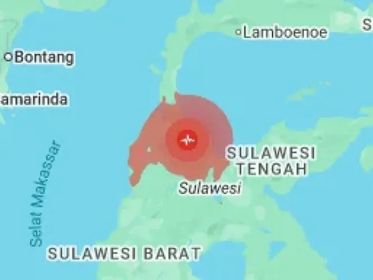
The tremor struck at 06:37:42 WIB on June 8, with its epicenter at 5.69°N – 125.05°E, approximately 236 kilometers northwest of Tahuna in the Sangihe Islands, at an initial depth of 105 kilometers. Within minutes, Indonesia's Meteorological, Climatological, and Geophysical Agency (BMKG) issued tsunami warnings for Sulawesi, Gorontalo, Central Sulawesi, Maluku, and East Kalimantan.
As seismic stations across the region reported their data, BMKG revised the parameters. The depth was adjusted to 47 kilometers; the epicenter shifted to 5.80°N – 125.14°E, roughly 244 kilometers northwest of Karatung Island. The 58-kilometer difference in depth may sound substantial, but in tsunami early-warning operations it represents routine refinement, not error correction. A warning system cannot wait for perfect data.
The underlying principle is unforgiving: seismic decision-making in the first minutes must rely on the best data at hand, not the best data that could eventually be assembled. Waves do not wait for model perfection.
The warnings were issued at two alert levels. Twelve districts were placed on high alert, the most critical status, including the Sangihe Islands, Manado city, parts of North Minahasa, northern Bolaang Mongondow, northern Gorontalo, Buol, and Toli-Toli. Ten additional districts received a lower alert, including the Talaud Islands, Bitung city, Halmahera, Ternate, Tidore, and three East Kalimantan regencies — Kutai Timur, Bulungan, and Nunukan.
Nine Stations, One Peak
Between 06:58 and 08:20 WIB, tidal sensors across the region recorded successive waves at nine locations. Tahuna, nearest the epicenter, reported the first arrival: 0.30 meters at 06:58. Bitung followed two minutes later with 0.29 meters. The waves propagated outward — Kedi/Loloda 0.09 meters, Ulu Siau 0.18 meters, Melonguane ranging from 0.19 to 0.32 meters, Paleleh 0.45 meters, Tanjung Sidupa 0.32 meters, Ternate 0.14 meters.
The peak came at Talengan, on the Sangihe Islands, at 08:20 WIB: 0.75 meters — nearly waist-high on an adult, recorded 82 minutes after the quake. Official classifications call this a "small tsunami." The label loses force when applied to moving water near inhabited shores — enough to topple a person standing in the shallows and sweep them seaward. A modest height offers no guarantee of safety.
Subduction Zone, Not Megathrust: A Distinction That Matters
One immediate question that circulated on social media concerned the earthquake's source. Wijayanto, director of earthquakes and tsunamis at BMKG, clarified that this was not a megathrust earthquake. The source was the Philippine Sea Plate subduction zone.
The difference is not merely technical; it shapes how the public understands the scale of the threat. Megathrust ruptures, like those that triggered the 2004 Indian Ocean tsunami in Aceh, arise from enormous contact zones between plates with vast accumulated energy — potential magnitudes above 8.5 and tsunami waves tens of meters high. The Philippine Sea Plate subduction zone operates under different geometry and energy capacity. BMKG felt compelled to make this distinction because of a dual communication risk: a public that confuses the two types might overreact each time "megathrust" is mentioned, or conversely, underestimate earthquakes that are not megathrust but still dangerous. Monday's event demonstrated that even a non-megathrust subduction zone can generate real waves reaching populated coasts. The Sangihe-Talaud region will remain in this subduction zone regardless of terminology — a permanent geographic fact, not a reassuring one.
Evacuation Alerts Arrived Before the Waves
Tony Agus Wijaya, head of the BMKG Manado Geophysics Station, explained that evacuation recommendations were transmitted sequentially to high-alert districts. The Sangihe Islands received its recommendation at 07:51 WITA — equivalent to 06:51 WIB, fourteen minutes after the quake and seven minutes before the first wave struck Tahuna. Manado and northern Minahasa received theirs at 08:12 WITA; northern parts of Minahasa at 08:14 WITA.
This represents a concrete technical advantage: the chain from seismic sensor to institutional decision to official message moved faster than wave propagation toward the nearest coast. In Talengan, where the highest waves were recorded, the evacuation recommendation preceded the water by more than an hour.
Whether that recommendation then translated into functioning sirens, mosque loudspeakers, and organized columns of residents moving away from the beach is a question beyond the meteorology center's purview. Coastal residents in Manado and Bitung were reported to have panicked; whether that panic was organized and directed to safety zones remains unclear. Field assessment will answer what instruments alone cannot.
First Trial for New Agency Head
At 10:15 WIB, BMKG head Teuku Faisal Fathani declared the tsunami warning lifted. After monitoring tidal data from the sensor network for three and a half hours and confirming no further sea-level rise posed a threat in any district, he ordered the alert withdrawn.
This was the first major disaster event managed by Fathani since his appointment on November 3, 2025, succeeding Dwikorita Karnawati.
No official reports of deaths or significant building damage were recorded in Indonesia through the warning period. BMKG logged 20 aftershocks by 10:00 WIB, ranging from magnitude 3.9 to 6.7 — two strong enough to be felt. The frequency and intensity of aftershocks over the next 48 hours will indicate whether the stress in the subduction zone has truly dissipated or merely paused.
Questions Remain
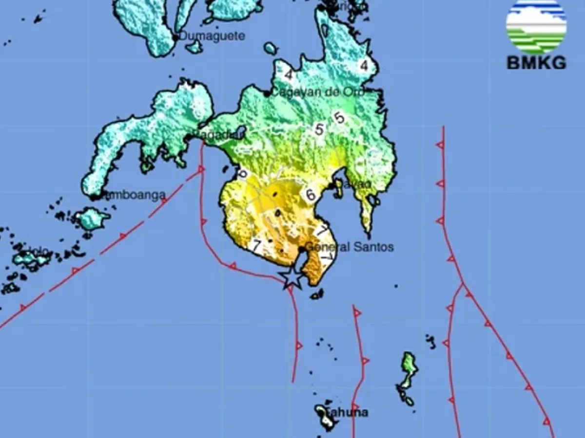
The picture across the border in the Philippines is incomplete. International media reported deaths and a small tsunami in Mindanao; casualty counts remained in flux. The Sulawesi Sea geologically connects Indonesia and the Philippines — a single earthquake strikes both sides of the border simultaneously. Coordination between BMKG and PHIVOLCS (the Philippine Institute of Volcanology and Seismology) emerges as a relevant topic for post-event review, including whether the two parallel warning systems exchanged information in real time.
Domestically, more fundamental questions await field data. Assessments by BMKG and BNPB (the National Disaster Management Authority) in the Sangihe, Talaud, Manado, and Bitung districts will determine whether casualties or damage went unreported, particularly on remote islands where communication access is limited.
The warning system proved it could move from center to district faster than the waves themselves. The final leg — from district to village to the ears of people living closest to the shore — awaits verification.